


Fujian Province is located on the southeast coast of China, bordering the Taiwan Strait to the east, Zhejiang Province to the northeast, Jiangxi Province to the northwest, and Guangdong Province to the southwest, with a land area of 124,000 square kilometers. Fujian Province governs 9 prefecture-level cities including Fuzhou City, Xiamen City, Putian City, Sanming City, Quanzhou City, Zhangzhou City, Nanping City, Longyan City, and Ningde City, and has Pingtan Comprehensive Experimental Zone; It consists of 11 county-level cities, 31 municipal districts and 42 counties.
Fujian Province is dominated by mountainous and hilly terrain, the area of hilly mountains accounts for about 80% of the total area of Fujian Province, mainly in the western part of midlands of Fujian, most of which belong to the Wuyi Mountains.
There are narrow plains in the eastern coastal areas of Fujian Province, which are small. The terrain of Fujian Province is generally high in the northwest and low in the southeast. In the west and central parts, the western Fujian mountain belt and the central Fujian mountain belt are formed, and disconnected valleys and basins between the two mountain belts. Fujian has many rivers, including the Minjiang River, Daijiang River, Jiulong River, etc.
The total length of the coastline of Fujian Province is about 3,572 kilometers, with many bays, peninsulas, and islands. Most of the coasts are bedrock coasts, with deep-water stretches of coast and rich port resources. The main ports include Quanzhou Port, Xiamen Port and Fuzhou Port, etc. Pingtan Island is the largest island in Fujian Province, with a total area of about 274 square kilometers.

Fuzhou Tourism Map
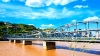
Fuzhou is a prefecture-level city and the provincial capital of Fujian Province. It is located in the east of Fujian Province, the lower reaches of the Minjiang River, and the coastal areas. The landform is a typical estuarine basin, mainly mountainous and hilly; It is a typical subtropical monsoon climate, warm and humid, evergreen all year round. As of October 2023, Fuzhou has jurisdiction over 6 municipal districts, 6 counties, and 1 county-level city, with an area of 11,1968.53 square kilometers.

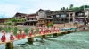
Xiamen Tourism Map
Xiamen is a prefecture-level city and a sub-provincial city in Fujian Province. It is located on the southeast coast of Fujian Province, connected with Zhangzhou and Quanzhou. It is mainly coastal plain, platform, and hills, and it has a mild and rainy subtropical oceanic monsoon climate. As of October 2023, Xiamen has jurisdiction over 6 districts, covering an area of 1700.61 square kilometers.

Putian Tourism Map
Putian is a prefecture-level city in Fujian Province. It is located on the central coast of Fujian Province, with Fuzhou to the north, Quanzhou to the south, Dai Yunshan to the west, borders the Taiwan Strait to the southeast. The terrain of Putian City is high in the northwest and low in the southeast, with a saddle-like cross-section. It is a typical subtropical Marine monsoon climate, with a land area of 4200 square kilometers. As of July 2022, the city has jurisdiction over 4 districts and 1 county.

Sanming Tourism Map
Sanming is a prefecture-level city under the jurisdiction of Fujian Province, located in the west and northwest of Fujian Province, east of Fuzhou City, west of Jiangxi Province, southeast of Quanzhou City, southwest of Longyan City, north of Nanping City, an area of 22,965 square kilometers. By the end of 2021, Sanming has jurisdiction over 2 districts, 8 counties, and 1 county-level city.

Quanzhou Tourism Map
Quanzhou is a prefecture-level city under the jurisdiction of Fujian Province, located in the southeast of Fujian Province, and is one of the three major central cities in Fujian Province. It is surrounded by mountains and sea, with hills, valleys, and basins scattered among them. The terrain is high in the northwest and low in the southeast, and mountains and hills account for four-fifths of the total land area. The land area is 11015 square kilometers, and the sea area is 11360 square kilometers. As of June 2023, the city has jurisdiction over 4 municipal districts, 5 counties, and 3 county-level cities.

Zhangzhou Tourism Map
Zhangzhou is located in the southern part of Fujian Province. The city has a mountainous terrain, with higher land in the northwest and lower land in the southeast. It has a subtropical monsoon humid climate, with mild weather and abundant rainfall. The city covers a land area of 12,600 square kilometers, with an additional 18,600 square kilometers of sea area. As of October 2022, it has jurisdiction over 4 municipal districts and 7 counties.

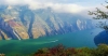
Nanping Tourism Map
Nanping City is a prefecture-level city under the jurisdiction of Fujian Province, located in the north of Fujian Province, southeast of the north section of Wuyi Mountains, at the junction of Fujian, Zhejiang, and Jiangxi provinces, commonly known as "Northern Fujian Province", with a total area of 26,300 square kilometers. It has jurisdiction over 2 municipal districts, 5 counties, and 3 county-level cities.

Longyan Tourism Map
Longyan, commonly known as the Western Fujian, is a prefecture-level city under the jurisdiction of Fujian Province. Located at the junction of Fujian, Guangdong, and Jiangxi provinces in the west of Fujian Province, it is an important mining area and forest area of Fujian Province, with a total area of 19,028 square kilometers. As of June 2023, Longyan City has jurisdiction over 2 municipal districts, 4 counties, and 1 county-level city.

Ningde Tourism Map
Ningde, commonly known as Eastern Fujian, is a prefectural city under the jurisdiction of Fujian Province. It is located on the northeast coast of Fujian Province and the East Fujian region. It is adjacent to the East China Sea in the east, Nanping City in the west, Fuzhou, the provincial capital in the south, and Zhejiang Province in the north. It has a land area of 13,500 square kilometers and a sea area of 44,600 square kilometers. As of October 2022, it has jurisdiction over 1 district, 6 counties, and 2 county-level cities.