Location
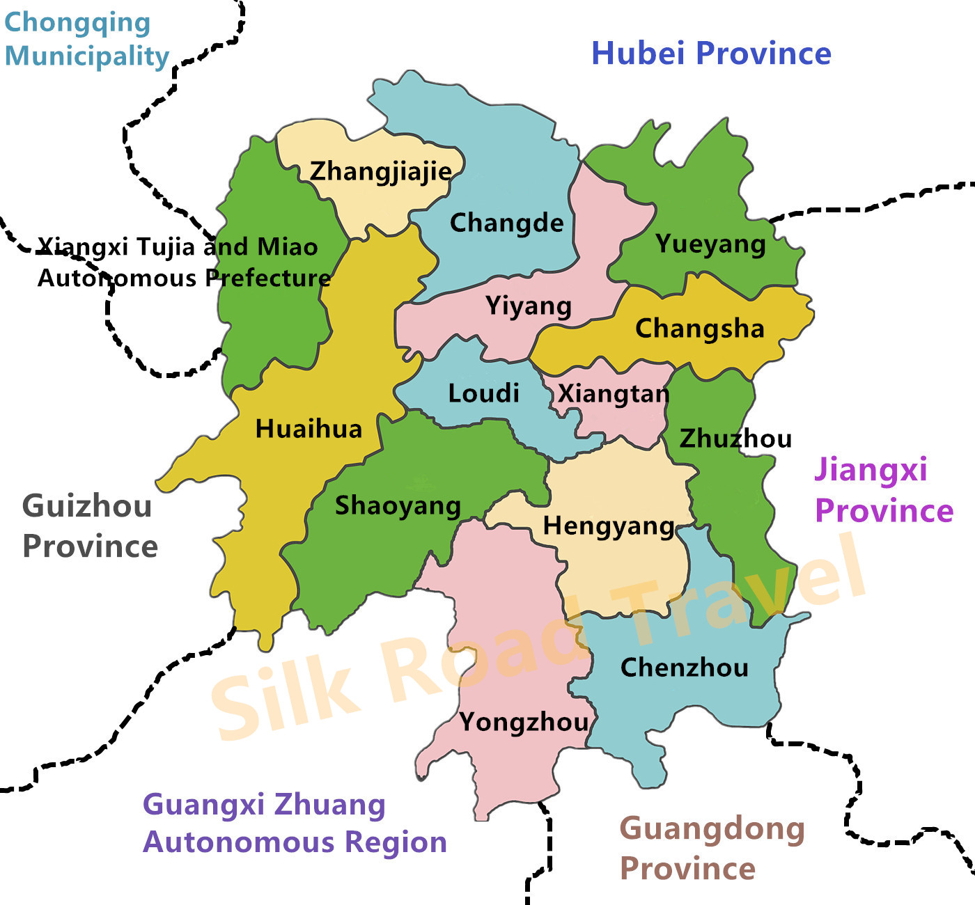
Located in the middle reaches of the Yangtze River, Hunan Province is mostly situated south of Dongting Lake, hence its name. The Xiangjiang River traverses the north and south of Hunan, giving it the abbreviation "Xiang". Hunan borders Jiangxi to the east, connects with Guizhou through the Yunnan-Guizhou Plateau to the west, adjoins Chongqing via the Wuling Mountains to the northwest, neighbors Guangdong and Guangxi to the south, and shares a border with Hubei to the north. With a total land area of 211,829 square kilometers, accounting for 2.21% of China's total land area, Hunan ranks tenth among all provinces, municipalities, and autonomous regions in China.
In Hunan, you can find not only plains, basins, and lakes, but also hills and mountains. These peaks, either soaring into the clouds or extending continuously like a giant dragon wriggling and coiling, embrace the vast land of Hunan tightly. They bear witness to the vicissitudes of time and embody the resilience and wisdom of the people of Hunan. Here, you can sense the solidity of the mountains, hear the whispers of the wind, and touch the pulse of nature.
Nestled among these majestic mountains and steep ridges, flow the rivers of Hunan. These rivers, either rushing and tumultuous or calm and serene like a mirror, resemble silvery ribbons that connect the land of Hunan. They nourish this soil and nurture the civilization of Hunan, a place where you can feel the vitality of the water, hear its songs, and taste the sweetness of nature.
Topographical Characteristics
Hunan Province is situated in a transitional zone between the Yunnan-Guizhou Plateau and the Jiangnan Hills, as well as the Nanling Mountains and the Jianghan Plain. Its topography exhibits a horseshoe-shaped landform, surrounded by mountains on three sides and opening towards the north. The northern part of Hunan is the Dongting Lake Plain, the lowest and flattest region in the province, with an altitude mostly below 50 meters. The lowest point in Hunan is Yanghuyuan in the Yuelu District of Changsha City, with an altitude of 21.6 meters.
In addition, Hunan spans two major river systems: the Yangtze River and the Pearl River, and belongs to the subtropical monsoon humid climate. With its unique geographical location, Hunan borders multiple provinces and boasts a diverse range of topographical features. Here, the water system is well-developed, and the climate is pleasant, making it one of the important birthplaces of Chinese civilization.
Regional Division
Hunan Province has 13 prefecture-level cities and 1 autonomous prefecture. Prefecture-level cities are Changsha City (the capital city of Hunan), Zhuzhou City, Xiangtan City, Hengyang City, Shaoyang City, Yueyang City, Changde City, Zhangjiajie City, Yiyang City, Chenzhou City, Yongzhou City, Huaihua City, Loudi City; The autonomous prefecture is Xiangxi Tujia and Miao Autonomous Prefecture (Jishou City). The Map is as follows:

Want to know what to experience, where to go, and what to eat in Hunan?
>>>Hunan Best Things To Do will give you more advice ~


