


 The Gomgga Scenic Area
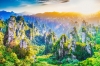
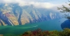
Gongga Mountain National Scenic Area, located at the junction of Kangding City in Sichuan Province and Luding County in Garze Tibetan Autonomous Prefecture, is one of China's renowned high mountains and the highest peak in western Sichuan, towering at 7556 meters above sea level. In Tibetan, "Gong" means ice and snow, while "Ga" denotes white, hence it is known as the "White Ice Mountain". The Gongga Mountain Scenic Area is celebrated for its magnificent natural landscapes and rich biodiversity. Part of the Himalayas, the area is surrounded by numerous glaciers, snow peaks, and alpine meadows. Its glacier scenery is particularly spectacular, attracting climbers and adventurers alike.
Gongga Mountain boasts a rich ecological environment, hosting rare species such as giant pandas and golden snub-nosed monkeys. The establishment of nature reserves has played a crucial role in their conservation. In Tibetan Buddhism, Gongga Mountain holds significant spiritual importance, revered as one of the sacred mountains, drawing pilgrims and devotees annually. Renowned for its majestic natural scenery and profound cultural significance, Gongga Mountain Scenic Area is not only a hub for tourism, exploration, and scientific research, but also a prime destination for exploring natural beauty and cultural heritage.
The best locations for viewing Mount Gongga
Lenggacuo
Location: Western side of Mount Gongga
Altitude: 4600 meters
Lenggacuo is situated behind Mujide Village on the western slope of Mount Gongga, approximately a 3-hour hike (horseback riding is also available), making it one of the best lake viewpoints for observing the main peak of Mount Gongga. The most beautiful time here is during sunset when Gongga Mountain is bathed in golden sunlight, presenting a spectacular sight as the "King of Sichuan Mountains". Lenggacuo is one of the few places where you can see the reflection of Gongga Mountain. There are two routes to Lenggacuo: Route A involves hiking or horseback riding from Mujide Village, covering about 3.5 km one way; Route B starts from Shang Chiji West Village with a local motorcycle ride, although the motorcycle cannot go directly to the lakeside, requiring a short hike. It is recommended to camp overnight at Lenggacuo; typically, the morning offers calmer winds and a quieter lake surface, enhancing the visibility of the reflection.


Zimeiyakou
Location: Western side of Mount Gongga
Altitude: 4600 meters
Zimeiyakou is the closest point to Mount Gongga, only 5 kilometers from its main peak, making it the best viewpoint on the western side to admire Gongga Mountain bathed in golden sunlight and surrounded by sea of clouds. Spring (March to May) and autumn (September to November) are the ideal seasons to visit Zimeiyakou for viewing. These seasons typically have clear skies and fewer clouds, providing better visibility of the snow-capped mountains. Arriving at Zimeiyakou before 6 AM or around 7 PM is recommended, as the sunlight at these times casts the mountain in the best angle, highlighting its contours and enhancing its colors with various shades and light changes. Against the backdrop of golden sunlight, Gongga Mountain's silhouette appears clearer, its texture more pronounced, and its colors richer and more varied, creating a mesmerizing and dreamlike landscape reminiscent of a fairyland.


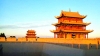
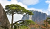
Hailuogou Glacier Park
Location: Eastern slope of Mount Gongga
Length of Valley: Approximately 30.7 kilometers
Hailuogou Glacier Park is a significant part of the Mount Gongga scenic area and a national-level nature reserve. It originates from the eastern slope of the "King of Sichuan Mountains," Mount Gongga, spanning about 30.7 kilometers with an area of approximately 220 square kilometers. Formed around 16 million years ago, the glaciers in Hailuogou are classified by geologists as modern marine-type glaciers. Located in the transitional zone of the Sichuan Basin, Hailuogou features a diverse landscape including high mountains, modern glaciers at different altitudes, alpine lakes, hot springs, virgin forests, and a rich variety of rare flora and fauna. It represents a complete bioclimatic zone where visitors can experience the natural changes of "four seasons in one valley, different weather every ten kilometers." Hailuogou experiences its coldest temperatures in January, with lows reaching around -12°C and an average daily temperature of 3.9°C. In contrast, August sees the highest temperatures with an average of around 13°C and highs up to 22°C. The annual average temperature is 5°C, and the snow cover can reach up to 35 centimeters thick.


Yaha Pass
Location: Southwest slope of Mount Gongga
Altitude: 4568 meters
Yaha Pass is approximately 30 kilometers in a straight line from the main peak of Mount Gongga, offering an excellent vantage point for a close-up view of the "King of Sichuan Mountains". Mount Gongga was ranked second among "China's Top Ten Most Beautiful Sacred Mountains" by China National Geographic Magazine. Located on the southwest slope of Gongga, Yaha Pass is less frequented due to the challenging road conditions, attracting fewer visitors. However, it is highly favored by many photography enthusiasts for capturing Gongga Mountain's exceptional forms. One of the most commendable experiences at Yaha Pass is witnessing Gongga Mountain illuminated by the shimmering Milky Way in the serene moments of the night.


Best Time To Travel
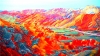
The best seasons for tourism are spring and autumn, due to their favorable climate conditions. In spring (April to June), temperatures gradually warm up with comfortable daytime temperatures, ideal for hiking and mountain activities. It's also the melting season in the Gongga Mountain region, adorned with blooming mountain flowers and lush greenery, perfect for natural photography and sightseeing. Autumn (September to November) offers stable weather and moderate temperatures, making it the optimal time to avoid the rainy season. Despite significant temperature differences between morning and evening, daytime skies are sunny and air crisp, ideal for high-altitude trekking, mountain climbing, and photography.
These seasons showcase the most enchanting natural landscapes. In spring, the rejuvenation of nature contrasts Gongga Mountain's snowy peaks with vibrant green vegetation, creating a lively canvas. Autumn brings a colorful spectacle with crimson leaves covering mountains and valleys, presenting picturesque scenery. The distinct hues of mountains, rivers, and streams during this time provide excellent opportunities for sightseeing and photography. Both spring and autumn offer a rich array of tourist activities. Spring allows for enjoying flower seas, high-altitude trekking, and birdwatching, while autumn is ideal for extended hikes and mountain exploration in safe and comfortable conditions with stable weather and good visibility.
.jpg")

Notes for Visitors
Preventing Altitude Sickness: Mount Gongga is located at high altitude. Please be aware of symptoms like headaches and nausea. Adequate rest and staying well hydrated are essential.
Weather Variability: The climate around Mount Gongga is unpredictable with significant temperature differences between day and night. It is advisable to carry warm clothing and rain gear to prepare for sudden weather changes.
Physical Preparation: Hiking and climbing Mount Gongga require strong physical fitness. It's recommended to undergo physical training and preparation in advance.
Safety Awareness: For high-altitude trekking or climbing, understand local routes and weather conditions. Choose safe itineraries and ensure you have appropriate gear.
Environmental Protection: Respect local environment and culture. Avoid disturbing wildlife and adhere to local tourism regulations and ethical guidelines.
Food and Water: Bring snacks and ample water as food and water resources in high-altitude areas may be limited or unstable in quality.
Travel Routes
Classic Hiking Route:
Lao Yulin Village -> Gexi Grassland -> Liangcha River Campsite -> Xia Riwuqie Campsite -> Shang Riwuqie Campsite -> Riwuqie Pass -> Moxi Valley Tail Campsite -> Gongga Temple -> Zimei Village -> Bawang Lake -> Boundary Stone - Caoko Township. This classic hiking route spans approximately 70 kilometers and takes 4-6 days to complete.
Horse Riding Route:
Route: Xinduqiao -> Quanhua Beach -> Lengga Lake -> Gongga Mountain Township -> Zimei Pass. Horse riding costs 200 for one way and 400 for round trip, with a 30 yuan entrance fee.